Day 2: Discussion:
Task 2: Identifying key elements of a model
Today, we identified that this was a model, or a representation of the school, and that it is NOT the school in an of its self. We then later discussed what elements do we need in order to make this model / representation meaningful to you as the scientist and for those who may be examining your notes / work?
Key elements needed for this model *(aka; map) were brought up by students:
During discussion, we collectively title the image, and decide what parts to label a few parts of the image, develop a key, discuss any observations they make along the way, like the fact that the trailers are missing - which leads to what year the photo is (2013), which then leads to modifying the title. The conversation also leads to which direction is North, and how can we tell - which then leads to us all going out side for about 4 minutes to discuss this, then place a compass on our "model", or map.
I then lead the discussion towards scale and ask them how do we find that? After a discussion of how they can do it, I say - "okay, do it! Go and come back in 10 minutes and find your scale."
I then have the students put their newfound scale on the board and have a short discussion. For most periods, I've ended here. For some periods, I have not gotten here yet - but instead we had a discussion about where the hallway is in the school so that we can better measure it. It all depends on the direction of the conversation and how it relates to the overall challenge.
Task 2: Identifying key elements of a model
Today, we identified that this was a model, or a representation of the school, and that it is NOT the school in an of its self. We then later discussed what elements do we need in order to make this model / representation meaningful to you as the scientist and for those who may be examining your notes / work?
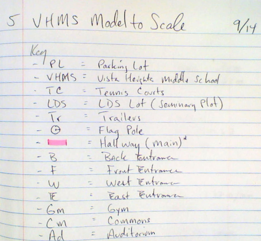
Key elements needed for this model *(aka; map) were brought up by students:
- A key or legend with symbols
- Title (Vista Heights Middle School - 2013)
- Labels of parts
- Compass (Arrow pointing North)
- Scale
During discussion, we collectively title the image, and decide what parts to label a few parts of the image, develop a key, discuss any observations they make along the way, like the fact that the trailers are missing - which leads to what year the photo is (2013), which then leads to modifying the title. The conversation also leads to which direction is North, and how can we tell - which then leads to us all going out side for about 4 minutes to discuss this, then place a compass on our "model", or map.
I then lead the discussion towards scale and ask them how do we find that? After a discussion of how they can do it, I say - "okay, do it! Go and come back in 10 minutes and find your scale."
I then have the students put their newfound scale on the board and have a short discussion. For most periods, I've ended here. For some periods, I have not gotten here yet - but instead we had a discussion about where the hallway is in the school so that we can better measure it. It all depends on the direction of the conversation and how it relates to the overall challenge.
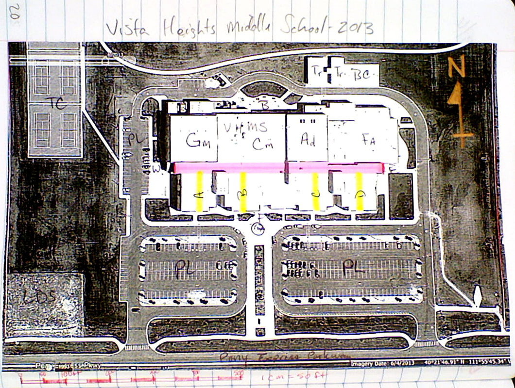 |  |
Task 3: Figure out how you can calculate how long the hallway is.
To do that, you'll need to create a scale. To do that, you'll need to:
Note to self:
To do that, you'll need to create a scale. To do that, you'll need to:
- measure a part of something "out there" that is visible on the map / image.
- measure that same part on the image.
- create a notable scale.
- then measure the hallway on the image.
- use your scale that you generated and calculate how long the hallway is in feet.
Note to self:
- I have all the students post all of their calculations and notes on the opposite page of their maps.
- When I had the students do this activity, I had them go outside to make a few measurements, then return back inside.
- I later had students post their numbers on the image projected in the front of the room.
- I then had students post their scale on the side of the board.
- When I had them calculate, I had them post their numbers in feet on the other side of the board.
- A small discussion ensued as to why the numbers were so vastly different. Some comments were made about accuracy and rounding. I also posted about students may not know how to do the math.
- We then measured using a walking measuring stick to see how close they were.
- This may lead to further discussion as to why numbers were way off, and we may need to spend about a half of a day to learn how to calculate scale, and do this activity over as a class, and recalculate for another item on the map.
- Further discussion on the following items:
- Importance of accuracy of the model
- Importance of measuring 2-3 times for accuracy.
- Where you measured is of utmost importance. I have a feeling that some students didn't know where to measure the beginning and end.
- Understanding how math is used to calculate
 RSS Feed
